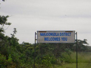
Nakasongola district came into existence in 1997. It is made up of one county. Buruli which was formerly part of Luwero District.
In the 1970s, during the Idi Amin regime era, Nakasongora gained sub-district status. The commission of inquiry into the local government system in 1987 recognized that Nakasongola was too far away from the administrative centre of Luwero to be administered directly from there hence suffered from relative neglect. This later became the basis for the creation of Nakasongola District in 1997. The main language is Lururi and Luganda.
Location
Nakasongola boarders the districts of Apac to the North, Masindi in the West, Luwero in the South and Kayunga in the Easy.
Population
It has a population of 125,297 people, 62,312 of which are females and 62,985 males.
Economic activities
Agriculture is one of the major activities with emphasis on Food crops such as Cassava, Maize, sweet potatoes, Sorghum, Bananas and finger millet.
Cash crops include Coffee and cotton.
Education services
The district has a total of 141 primary schools with 118 government, 7 private and 16 community schools. For secondary schools, the district has over 15 schools, 3 are government, 5 private and 7 community.
Health services
The district has 14 Government dispensaries (II), 5 health centres, 1 health centre (IV) and I hospital. More so, it has 3 private/NGO dispensaries, and Hospital.
Transport Network
The district is connected by a tarmac road to Masindi and Luwero District. The feeder-road network however is inadequate. Traveling within the district is a problem as means of transport are hard to get. This greatly affects transportation of agricultural produce within the city. Once products reach the tarmac road however, it finds a ready market both in the neighboring districts of Luwero and Masindi and as far as far away as Kampala.

 Posted in

